


The Salkantay Trek does not pass through an uninhabited area. Over the five days of hiking, you cross the lands of rural communities, high plains where families raise livestock, small settlements on the edge of the jungle, and villages that live off coffee and fruit. The people who set up your camp, carry your luggage on their mules, or sell you a granadilla along the way are local residents. Learning a little about each village changes the way you see the route: it stops being just a landscape and becomes a journey through the lives of the people who call it home.
From the highlands to the edge of the jungle in five days
The route descends from the high plains at the foot of the snow-capped mountain, where only ichu grass grows and horses and livestock are raised, to warm valleys covered with coffee plantations and fruit trees. This descent is reflected in the villages: higher up, muleteer families who live from herding and working with trekkers; lower down, farmers growing coffee, avocados, bananas, and granadillas.
In nearly all communities in the upper section, Quechua is spoken as a first language. In the jungle area, Spanish is more common, although many families came from the highlands and still maintain the language.
Mollepata: where the route once began on foot
Mollepata is an agricultural town in the province of Anta, on a hillside overlooking the Apurímac valleys. For years, it was the starting point of the Salkantay Trek on foot: groups would set off hiking from here to the high plains, before the road reached Soraypampa.
Today, most travelers only stop for breakfast, but the town remains the gateway to the route. Many muleteers and cooks working on the trek are from here or nearby communities.
Soraypampa: the muleteers’ plain
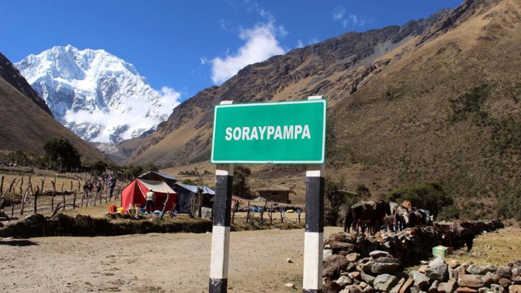
Soraypampa is not a village in the strict sense, but rather a plain at the foot of the snow-capped mountain where community families manage campsites, raise horses, and work as muleteers. It is your first real contact with high-altitude life.
For these families, the Salkantay snow-capped mountain is an apu, a sacred and protective mountain, and one of the most important in the Cusco region. Its name is commonly translated from Quechua as wild or untamed mountain. Humantay Lake, which you visit on the first day, is also a place of respect, and it is not unusual to see small offerings along its shores.
Huayracmachay: the cave of the wind
After crossing the mountain pass, the first rest stop on the descent is Huayracmachay. Its name comes from Quechua: wayra means wind and machay, cave. The name perfectly describes this place, exposed to the currents coming down from the snow-capped mountain.
It is more of a stopover than a village, with few houses and lunch areas for groups. It marks the start of the descent toward more sheltered valleys.
Chaullay and Collpapampa: the changing landscape
Chaullay and Collpapampa are small settlements where the change in ecosystem becomes clear. The first trees, bromeliads, ferns, and corn crops appear. The air becomes more humid and the temperature more pleasant.
Collpapampa is located at the confluence of two rivers and is one of the points where the road reconnects the route with the rest of the valley. Families combine farming with hosting groups that spend the night in the area.
La Playa: the fruit valley
La Playa, also known as Playa Sahuayaco, is a village on the banks of the Santa Teresa River, already deep in the edge-of-the-jungle region. The name does not refer to a beach by the sea, but to the river’s sandy banks.
It is the most productive agricultural area along the route. Avocados, bananas, granadillas, citrus fruits, and coffee are grown here, and much of the production leaves by road for Santa Teresa and Cusco. Walking through the village, you will see coffee drying areas and gardens beside the houses.
Lucmabamba: the coffee farms
Lucmabamba gets its name from lúcuma, an Andean fruit, and bamba, which in Quechua refers to a plain or flat area. It is an area of family-run farms devoted to coffee, grown under the shade of fruit trees.
Several families show groups the full process, from harvesting the beans to roasting them. It is one of the stops where you can best understand the local economy and how much work goes into every cup.
The climb to Llactapata begins from Lucmabamba, an Inca archaeological site with distant views of Machu Picchu. It is not a village, but it shows that this route was part of the network of paths connecting the sanctuary with other settlements.
Santa Teresa: the town that rebuilt itself
Santa Teresa is the largest settlement on the route and the district capital. In the late nineties, a mudslide destroyed much of the original town and the nearby hydroelectric plant. The town was rebuilt in a new location, which is why its layout is more modern than that of other villages in the valley.
Today, it is the connection point between the route and the rest of the valley, with a market, plaza, transportation, and the Cocalmayo hot springs on the outskirts.
Hidroeléctrica and Aguas Calientes: the end of the trail
Hidroeléctrica is not a village, but the place where the power plant that generates energy for much of the region is located. This is where the road ends and the walk alongside the railway begins.
Aguas Calientes, also called Machu Picchu Pueblo, grew around the railway line and the hot springs that give it its name. It is a young town devoted almost entirely to welcoming visitors to the sanctuary, and the final stop before visiting Machu Picchu.
To find out what you can buy, where to eat, and which services are available in each of these villages, check out shops and kiosks along the route, restaurants on the Salkantay Trek, and services available during the Salkantay Trek.
How to interact with communities along the trail
You are walking through other people’s land. A few simple gestures make a difference:
- Ask permission before taking photos of anyone, especially children and older people.
- Learn a greeting in Quechua. Allillanchu, used like how are you, opens up conversations.
- Buy fruit, coffee, and local products directly from families.
- Do not enter fields or animal pens without an invitation, even if the trail passes alongside them.
- Take your trash with you. There is no waste collection in the highlands, and everything left behind accumulates.
- Do not give candy to children. If you want to contribute, school supplies delivered through the guide or school are a better option.
Frequently asked questions
What does Salkantay mean?
The name comes from Quechua and is commonly translated as wild or untamed mountain. At more than 6 200 m s. n. m., it is one of the highest mountains in the Cusco region and an apu revered by local communities.
What language is spoken in the villages along the route?
In the upper section, Quechua is the main language and Spanish is the second. In the jungle area, Spanish predominates. With basic Spanish, you can communicate along the entire route, and your guide can help translate.
Can you stay with local families during the trek?
Some campsites belong to community families and operate on their land. Proper homestays are not common on this route, but you can ask your agency whether it offers an option of this kind.
Do communities benefit from tourism on the Salkantay Trek?
Yes. Many families work as muleteers, cooks, or campsite managers, while others sell products to groups. Choosing agencies that hire local staff and buying directly from families helps ensure those benefits stay in the area.