


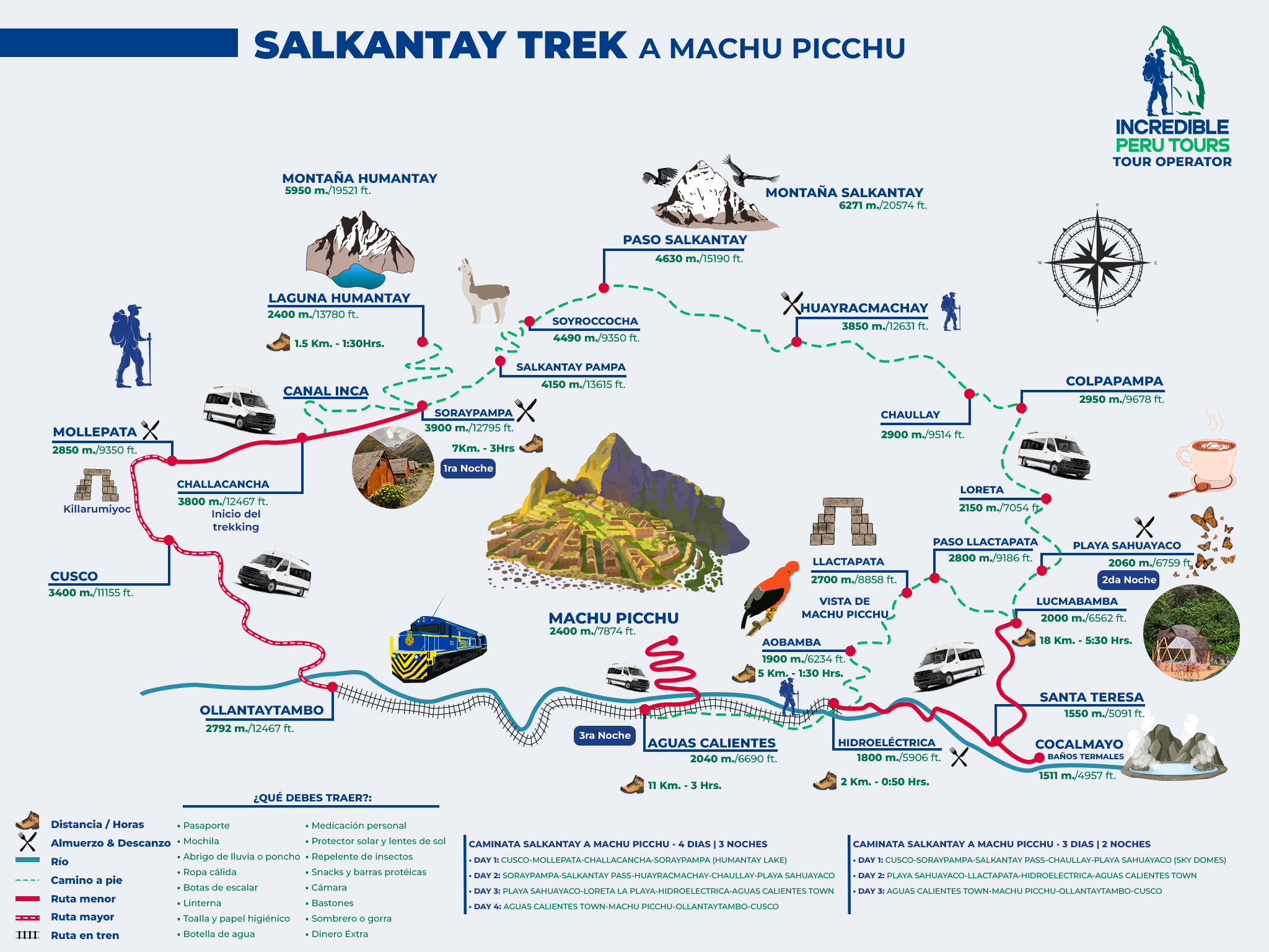
This section brings together Salkantay Trek maps to help you locate the main areas, landmarks, key stops, altitude changes and the final connection to Machu Picchu. The maps are for guidance and may vary depending on the booked itinerary, starting point, selected campsites and final route to Aguas Calientes.
Salkantay Trek overview map
The Salkantay Trek overview map makes it easier to understand the route’s location within the Cusco region and follow its progress from the high-altitude areas near Mollepata and Soraypampa to the Machu Picchu area. From a panoramic view, the route usually shows a journey from northwest of Cusco toward the warm valleys of La Convención.
On this map, it is useful to identify three references from the start: Soraypampa as the usual starting area for the hike, the Salkantay Pass as the high point of the route, and Aguas Calientes as the access point before Machu Picchu. The final connection can be made via Hidroeléctrica or through other logistical combinations, depending on the booked program.
The value of a complete overview is not in detailing every day, but in understanding that the route crosses very different environments in just a few days. It also helps distinguish the trekking trail from local roads, the railway from Hidroeléctrica to Aguas Calientes, and the bus access to the citadel.
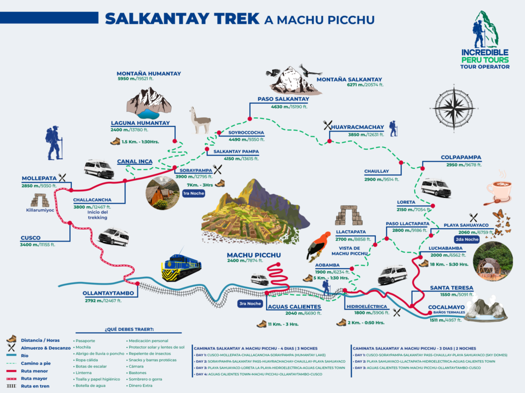
Map of the main Salkantay Trek areas
A map by areas divides the Salkantay Trek into broad geographical sections to make orientation easier. The first corresponds to the high mountains; then come the descending valleys and cloud forest; finally, the route reaches the surroundings of Machu Picchu.
This perspective helps anticipate where changes in scenery and altitude are concentrated. It also prevents a common mistake: assuming that the entire route has the same weather or vegetation. Higher sections can experience intense cold, while lower areas are usually warmer and more humid.
High mountain area
On the map, the high mountain area is located around Soraypampa, Humantay Lake, the Salkantay snow-capped mountain and the mountain pass. Soraypampa is approximately 3.900 m a.s.l.; routes to the lake and the main trekking pass begin from this area.
Humantay Lake is usually shown northeast of Soraypampa and at close to 4.200 m a.s.l. The Salkantay Pass, located at around 4.630 m a.s.l., is marked as the highest point on the usual route. On the map, this area is often represented with closer contour lines and references to snow-capped peaks or mountains.
- High mountain area: includes Soraypampa, Humantay Lake and the Salkantay Pass, the highest point on the route at approximately 4.630 m a.s.l. Cold weather, snow-capped peaks and mountain terrain prevail.
- Valleys and cloud forest area: after the pass, the descent begins toward Challway, Colpapampa, Lucmabamba and Playa Sahuayaco. The weather becomes warmer and more humid, and vegetation increases.
- Machu Picchu connection area: includes Llactapata, Hidroeléctrica, Aguas Calientes and Machu Picchu. From Hidroeléctrica, you can continue on foot or by train to Aguas Calientes.
Map of the main stops
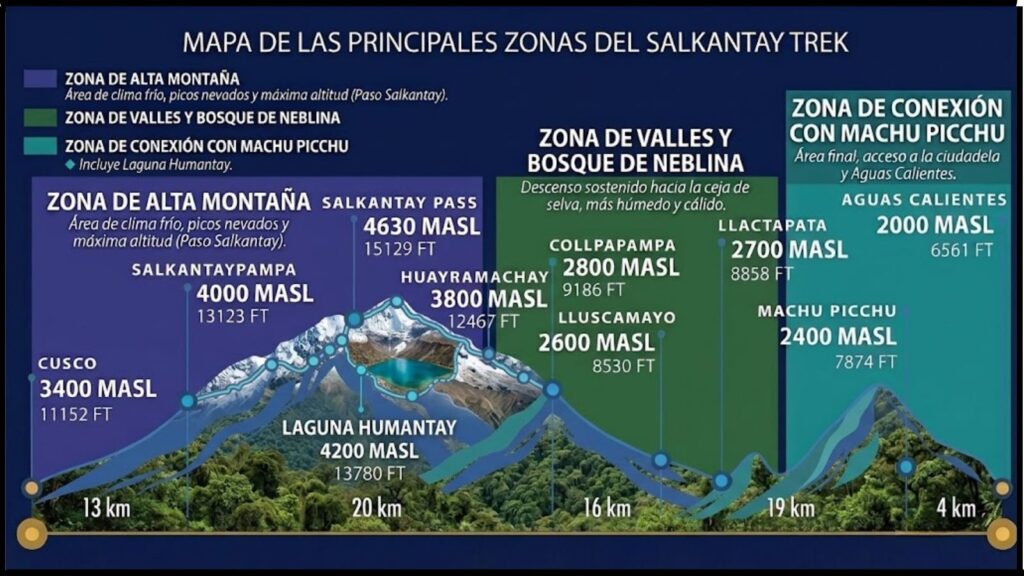
The map of the main Salkantay Trek stops should prioritize the places that truly help travelers find their way along the route. An image overloaded with detours, small hamlets or secondary stops can make it harder to read, especially for those reviewing the route before traveling.
The most useful points are usually the hiking start, Soraypampa, Humantay Lake, the Salkantay Pass, the main campsites or accommodations, Llactapata, Hidroeléctrica, Aguas Calientes and Machu Picchu. These references help connect the route with transport, rest stops and attractions along the way.
Starting and finishing points
The usual starting point for the hike is Soraypampa, although transportation generally begins in Cusco and may include a stop in Mollepata or other towns along the way. Some programs start from nearby areas, so the exact departure point should be confirmed on the map provided by the tour operator.
The geographical end of the trek is associated with Aguas Calientes and Machu Picchu. Aguas Calientes is the town where accommodations, restaurants and the train station are concentrated, while Machu Picchu is the final destination of the visit. On a clear map, these two points should be shown separately, as they are not at the same elevation or accessed by the same route.
Key stops and campsites
Soraypampa is usually one of the first important stops and may serve as a campsite or accommodation point, depending on the itinerary. Challway, Colpapampa, Lucmabamba and Playa Sahuayaco are frequent references during the descending days and help locate the progression toward lower areas.
Not all programs use the same overnight locations. Some agencies use campsites, others work with rural accommodations or domes, and some change the order of stops due to weather, availability or trail conditions. For this reason, the name of a campsite on a general map should not be interpreted as a guaranteed stop.
Main attractions shown on the map
Humantay Lake is usually marked as a detour from Soraypampa, separate from the main route toward the Salkantay Pass. On the map, it is best distinguished with a natural attraction icon or a secondary line, since visiting it may depend on the organization of the first day.
The Salkantay Pass is marked on the central route and serves as an altitude reference. Llactapata appears in the final part of the journey, before the connection to Hidroeléctrica or Santa Teresa, depending on the variation. Other relevant points may include the Salkantay snow-capped mountain and the Hidroeléctrica station, as long as they are shown without overcrowding the image.
Salkantay Trek altitude map
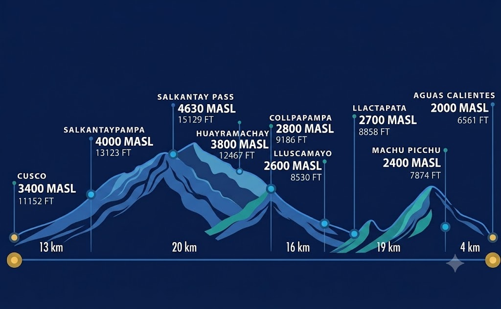
- It shows the main ascents, descents and altitude changes along the route. It helps you understand the shape of the journey, but it does not measure each traveler’s physical effort. The highest points are:
- Soraypampa: approximately 3.900 m a.s.l.
- Humantay Lake: close to 4.200 m a.s.l.
- Salkantay Pass: around 4.630 m a.s.l., the highest point on the classic route.
- Altitudes may vary slightly depending on the map or measurement method.
- The route begins with an ascent from Soraypampa toward Humantay Lake and the Salkantay Pass.
- After the pass, a gradual descent begins toward Challway, Colpapampa, Lucmabamba and Playa Sahuayaco.
- The route continues mostly downhill toward Hidroeléctrica and Aguas Calientes.
- The change in altitude explains the great variety of landscapes along the route.
How to interpret Salkantay Trek maps
To properly interpret Salkantay Trek maps, first distinguish the hiking trail from roads, railway lines and connecting paths. The map legend should indicate which type of line represents each route, as well as towns, campsites, attractions and transportation points.
It is also useful to review the scale and orientation. Two points may appear close together in a panoramic image but be separated by a considerable elevation change or a winding trail. Therefore, the map is useful for planning and orientation, but it does not replace the guide’s instructions or the logistical information in the confirmed itinerary.
Symbols, references and altitude levels
Tent, shelter or bed icons usually represent campsites and accommodations. Mountain symbols indicate snow-capped peaks, passes or summits; town symbols mark communities and service centers. Humantay Lake, Llactapata and Machu Picchu may appear with attraction or visitor-point markers.
Railway lines identify the connection between Hidroeléctrica and Aguas Calientes, while connection points may show stations, roads or bus access. Altitudes are normally displayed next to the place name or through contour lines. If the map uses colors, cooler or darker tones usually represent higher areas, although you should always check the specific legend.
Approximate distances between points
The distances shown on a Salkantay Trek map are approximate. They may change depending on the trail used, the exact starting point, detours to attractions, campsite location and the variations chosen to reach Hidroeléctrica or Aguas Calientes.
A common mistake is estimating travel time based only on kilometers. On this route, altitude, elevation gain and loss, trail conditions and weather directly affect progress. Use map distances as a location guide and review the daily details listed in your program before leaving Cusco.
Variations depending on the booked program
Not all maps show the same campsites, paths or final connections. Some variations include Santa Teresa and additional activities; others prioritize Lucmabamba, Llactapata or a direct transfer to Hidroeléctrica. Even within the same route, the order of accommodations may change due to operations or weather.
Before starting the trek, review the specific map provided by the agency and confirm meeting points, overnight accommodations, final transportation and the way to enter Machu Picchu. If you need to coordinate your itinerary, trains or final connections, you can contact the Salkantay.tours team directly to receive up-to-date information for your departure.